
Little Bushey
About Little Bushey
Little Bushey was a settlement in its own right until interwar development blurred the lines
between it, Bushey and the Heath.
What became Little Bushey Lane was the thoroughfare
from Aldenham to Bushey Heath. It stretched from Elstree Road to Aldenham Road and across farm land to Aldenham and
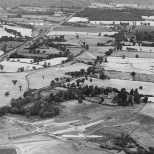
until the thirties had more farms than residences: From Little Bushey Farm where Woodfield
Rise is now, right down to Bushey Grange Farm opposite the cemetery. And until the late 19th
century it was part of Aldenham parish rather than Bushey.
You would be forgiven for not realising all this, as the only remaining acknowledgment are the destination boards on buses - a tradition carried on by Sullivan Buses on the 306.
But the real daily reminder of our heritage is Harts Farm and fields that stretch from Little Bushey Lane
to the A41 and M1. The footpaths that criss cross the fields linked us to Aldenham until the
A41 and M1 severed them. Many residents remember cows grazing the fields before
Harts Farm became a stables, and fished in ponds and streams. It forms part of a green
corridor for wildlife untouched for centuries.
And if you take the footpath from opposite the old cemetery entrance, you pass the area that was once Bushey Grange Farm which older residents still remember. Continue until the path bends round and you can see the trees in the middle of the field to the right where Bushey Grange was until its demolition in the 1930s.
It is these parts of Little Bushey in the green belt that developers wish to build thousands of houses on despite the fact that these fields have been removed from the draft Local Plan. It is an aspiration we must all challenge.