
Objections
Objecting to the new Harts Farm planning application
The consultation for the new planning application closes on Thursday 30 January 2025.
Everyone in your household can send a letter via email to consult.planning@hertsmere.gov.uk or by post to Planning and Economic Development, Civic Offices, Elstree Way, Borehamwood WD6 1WA.
Alternatively, you can upload your objection directly onto the Hertsmere Planning portal here
These are the key objections:
Loss of Green Belt
There are no special circumstances why this area of green belt should be developed for housing. Government says that brown field sites be used before green belt. And remember, the site was removed from the Draft Local Plan.
There are no special circumstances why this area of green belt should be developed for housing. Government says that brown field sites be used before green belt. And remember, the site was removed from the Draft Local Plan.
Flood risk
The site and surrounding roads have been identified a flood plain by the Environment Agency ranging from medium to high risk. Little Bushey Lane already floods as does the new development at Rossway Drive. Although this new application tries to avoid some of the flood plain, 280 more houses will increase that risk.
The site and surrounding roads have been identified a flood plain by the Environment Agency ranging from medium to high risk. Little Bushey Lane already floods as does the new development at Rossway Drive. Although this new application tries to avoid some of the flood plain, 280 more houses will increase that risk.
Traffic
The development at Harts Farm fileds will generate some 1000 extra cars and fumes on the already congested Little Bushey Lane, particularly at peak times
Loss of wildlife
The inclusion of a flood plain in this site creates a unique biodiverse environment and lends itself to be a micro-nature reserve of wildlife including protected muntjac deer, pipistrelle bats and Canada geese.
Lack of sustainable transport
Little Bushey Lane is unsuitable for cyclists and buses and the 306 with its limited evening and Sunday services is 10 minute walk away. This makes the development entirely car dependent.
Objecting to the Harts Farm planning application at appeal
The planning application is going to appeal on Wednesday 3 May.
You have another opportunity to object to the development of Harts Farm fields and to make it easier for you, we have produced three alternative letters you can use to voice your objections.
Everyone in your household can send a letter.
Please go to our downloads page and select one of the templates. The deadline is Thursday 6 April.
Objecting to the Harts Farm outline planning application
Full information on why Harts Farm fields should not be developed can be seen further down this page, but these are the key points;
Loss of Green Belt
There are no special circumstances why this area of green belt should be developed for housing. Government says that brown field sites be used before green belt.
Fall in housing demand
Housing demand has fallen according to Government figures as has been highlighted by both the CPRE and Hertsmere opposition councillors.
Traffic
The development at Harts Farm will generate some 1200 extra cars on the already congested Little Bushey Lane, more with the proposed school. In a recent Little Bushey Community traffic study, the figures demonstrated an increase of 12% in three years. The biggest being 0900-0930 with an increase of 32 %.
Flood risk
The site and surrounding roads have been identified a flood plain by the Environment Agency ranging from medium to high risk. Little Bushey Lane already floods as does the new development at Rossway Drive. 310 more houses and a school will increase that risk.
Loss of wildlife
The inclusion of a flood plain in this site creates a unique biodiverse environment. This area, which is constantly sodden can be considered to be a water meadow and coupled with the hedgerows, lends itself to be a micro-nature reserve of wildlife including protected muntjac deer, pipistrelle bats and Canada geese.
Lack of public transport
Little Bushey Lane is unsuitable for buses and the 306 with its limited evening and Sunday services is 10 minute walk away. This makes the development entirely car dependent.
Loss of ancient rights of way
Two ancient Right of Way public footpaths that cross the land giving people the opportunity to visit the wildlife area. Marked as B40 and B33 they are designated as ‘definitive’ on all walking maps and maintained by Hertfordshire County Council.
Sending your objection
Via Hertsmere planning portal using your own comments or our standard letter which you can download here.
By email quoting 22/1107/outline to consult.planning@hertsmere.gov.uk
By post quoting 22/1107/outline to Planning Consultation, Hertsmere Borough Council, Civic Offices, Borehamwood WD6 1WA
All objections must be submitted by Monday 25 July.

Environment
The eco-environment
The Harts Farm site is home to an established flood plain on two sides. The inclusion of a flood plain creates its own dynamic mix in this unique bio diverse environment. This area, which is constantly sodden even in summer months and can be considered to be a water meadow, coupled with the hedgerows, lends itself to be a micro-nature reserve.
There are also two ancient Right of Way public footpaths that cross the land giving people the opportunity to visit this creative wildlife area. Marked as B40 and B33 on the illustration, they are designated as ‘definitive’ on all walking maps and maintained by Hertfordshire County Council. To learn more about our local footpaths, please visit the Bushey and District Footpaths Association website.
Although there are other places in the county that offer similar environments, not all are accessible to the public and most importantly, there are no other places in Bushey that offer all these vital constituents in one place.
Wildlife
There has been a recent and noticeable decline in foraging wildlife like badgers and hedgehogs. Even rabbits and hares are becoming scarce. These are animals that were often in this area, are now rarely seen and too often only as carcasses on the roadside.
They are slowly being squeezed out of their natural habitat and forced to cross human infrastructure that has ever-increasing traffic. The band of land that runs through the Harts Farm fields proposal gives a last remaining passage, allows wildlife from other areas to come here to feed.
Specific species that are using this land include:
- a colony of pipistrelle bats is confirmed to be on the site. Over the years their habitats eg hedges, ponds and old grassland, where bats like to hunt, have declined in number and they have also lost many of their traditional roosting places, such as hollow trees. Pipstrelle bats are protected under Schedule 2 of the Conservation Regulations Act, 1994;
- a permanent family of Canada geese and a larger migrating colony that comes twice a year. Canada geese have life-long mates and are a beautiful addition to the environment. Relying on the water meadow and flood plain for their food source, Canada geese are protected under the Wildlife and Country Act, 1981; and
- muntjac deer who are commonly seen coming in and out of the hedgerows that provide cover for these naturally timid creatures. Muntjac deer are protected under the Deer Act, 1991.
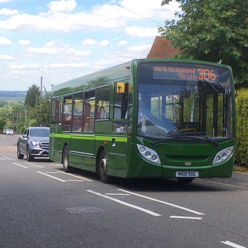
Public transport
The nearest bus service to any development on the Harts Farm fields is a 10-12 minute walk away.
The 306 route takes 13 minutes to Elstree and Borehamwood station and
11 minutes to Bushey station and only offers a half hourly peak service
that reduces to hourly in the evening. As it receives no County Council
subsidy, the last bus leaves Watford before 2200 and on Sundays the
service is two-hourly.
Whilst the Little Bushey
Community transport survey identifies that the 306 service has some
spare capacity off peak, it already suffers delays from traffic
congestion and frequent blockages in Chiltern Avenue and Farm Way.
To
reach Stanmore station the walking time to a bus is more than double,
but Herts County Council have long term plans to improve the Watford to
Edgware public transport corridor.
Stanmore
station is two miles away, and Bushey, a mile and a half away. Both
station car parks are at capacity. Bushey only provides a half-hourly
service into London Euston, although the London Underground service on
the Jubilee line is more frequent.
If the land
around Harts Farm becomes part of a larger garden village, then the
Campaign for Better Transport say that half the journeys from these
developments should be on foot or by bike or public transport. CFBT also
believe that no garden villages are likely to have a station within
walking distance and that they are too small for a spur line to be
built.
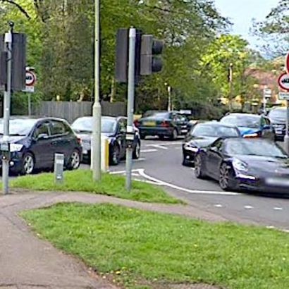
Traffic
Little Bushey Community has conducted a traffic survey by Wayside Avenue to ascertain the current number of vehicles using Little Bushey Lane in the morning.
Overall there has been an increase of 12% in the peak morning 0730-0930 traffic since 2018, with 1344 cars being counted. The biggest increase being 0900-0930 with an increase of 32 %
This survey did not take account of vehicles leaving the lower part of Little Bushey Lane in the direction of Aldenham Road.
The proposal by Hertsmere that more than 20 hectares of land be released from the Green Belt for 350 houses and a primary school, means that it is likely that another 1200 cars would be using Little Bushey Lane during peak periods. This does not take account of all the cars that will be generated by the Compass Park development further down the Lane which could add another 2,000.
Professional advice received on developer Redrow's own traffic study by Vectus states that it is not clear how and when a site visit was undertaken to establish the operation of the local highway network and that data was not collected from new developments to determine car ownership.
Further observations on the report are
- The key junctions identified are not realistic: There is also Sandy Lane and Bushey High Street/ London Road and others which should be considered, but in any event the roads and junctions are already overloaded
- The site scores low on Public Transport Accessibility Level
- Bus services are poor with 30 minute peak time intervals for the one bus and yet the site is considered a sustainable location
- No assessment of road safety has been undertaken, ignoring the many accidents at the Sandy Lane junction with the A41 and damage-only ones there and elsewhere
- Local traffic levels used suggest no increases in traffic yet no figures or summary provided
- Traffic calming speed humps will need to revisited
- On street car parking along Little Bushey Lane suggests that car ownership of residential properties is greater and its presence will be to the detriment of highway safety.
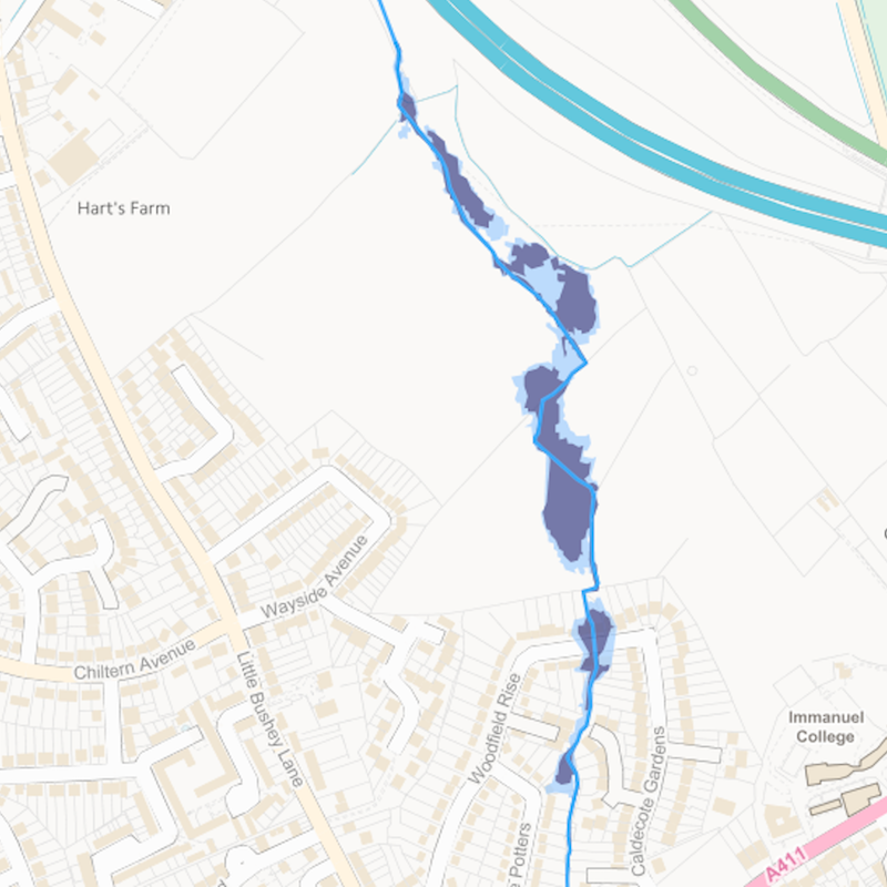
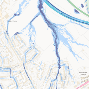
Flooding
The fact that the fields around Harts Farm are on a flood plain is not news to most people who live nearby. A stream cuts across the site from its source near Elstree Road as it travels downhill towards Sandy Lane.
The Environment Agency have identified land either side of the stream as being Zone 2 (light blue) and Zone 3 (dark blue) flood areas: Effectively medium and high risk. This is illustrated in map 1, issued by the Agency for development purposes. Any site containing a Zone 2 and 3 flooding requires a flood assessment, and the rest of the site - which is in Zone 1 - will also need an assessment by virtue of its size. Some houses in Woodfield Rise are in Zones 2 and 3.
We have drone footage of the site taken on a clear day and the extent of the water from the stream and associated surface water is evident. Harts Farm owners have also dug a number of drainage channels in order to alleviate the problem.
The dumping of spoil from the building of the M1 may well have exasperated the situation, but it is also known that historically there were a large number of ponds on the site.
Map 2 identifies current potential flooding from surface water with great swathes of the proposed site and adjacent roads already at low, medium and high risk. Little Bushey Lane is already flooded regularly by the fields and homeowners in The Squirrels and Wayside Avenue report similar problems.
Following reports of flooding in the new development in Rossway Drive, Little Bushey Community undertook a survey to identify the extent of the problem. 31% of homes revealed that they had been affected by flooding since the completion of the building works, indicating the likelihood of further development increasing flooding problems for more properties in the locality.
The revised National Planning Policy Framework, states that to meet the challenge of climate change, flooding and coastal change, plans should have regard to the cumulative impacts of flood risk, rather than just looking at the flood risk impact of individual development sites.
Objections to Local Plan
The consultation on the Draft Local Plan
opened on Monday 11 October 2021 and is now closed.
However due to a shambolic website
that falls short of public expectation, Hertsmere have been forced to
extend the deadline by two weeks until Monday 6 December in order sort
it out. This link takes you directly to the Bushey page where you may also leave objections. Harts Farm is B1 and is described as 'Land east of Little Bushey Lane.'
The CPRE also criticises the Council for claiming that they have to provide for housing need in full when they have failed to take into account protected land in reducing housing targets. The report also points out that Hertsmere has ignored central Government’s pledge to protect the Green Belt and that protecting it is not a strategic objective in the Plan and that giving over 12% of the Borough’s Green Belt to development will have a very significant impact on its character and appearance.
The CPRE also says the Plan underestimates the expected changes in demand for town centre and out-of-town sites which can be converted to residential use. The CPRE are now working on a more detailed technical review that they will publish in November.